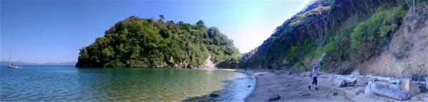
Taupo Point is the site of the most important pa along the eastern side of Mohua. It is extremely picturesque, with a steep rounded limestone ‘island’ and two adjacent limestone stacks, all now densely forested.
The pits and trenches on top are now buried within matai, titoki and nikau. The site has many karaka trees, offspring of those planted by Tumatakokiri as a source of food. The pa was located on the sandy ‘tombolo’ that linked the island to the granite mainland.
There is a lookout at the crest of the pa watching for visitors from West Coast, North Island, or the Sounds and Tasman Bay. It was from here and probably also the next beach to the north, Wharawharangi, that the waka came, in astonished belligerence, when Tasman’s two ships rounded Farewell Spit in December 1642.
Why is this place named “Taupo”? There are three possible explanations.
1. Early reports about the pa are recorded in Hilary and John Mitchell’s volumes Te Tau Ihu. In the 16th century a chief, Tumatakokiri, migrated from Taupo to the Cook Strait area and for some 200 years established a tribe of this name in Mohua, based at this pa. It is conceivable that the pa was named after their homeland. Barnicoat and Frederick Tuckett recorded the name Taupo in 1844.
2. The Dictionary of the Maori language by Henry Williams records the meaning of ‘taupo’ as “A rough black and yellow cloak” and “A ferruginous earth or stone.” The name Lake ‘Taupo’ was originally ‘Taupo-nui-a-Tia’ – the cloak of Tia, the discoverer of the lake. The black and gold flax that made his cloak was similar to the banding of the volcanic geology along the edge of the lake.
At Taupo pa the so-named “Brunner Coal Measure” is exposed along the southern shore, and the streams that descend from the granite behind also cut into this stratum. Close examination reveals a complex composition but in places, clearly visible along the beach immediately below where the pa was built, one can see bands of black coal and red-yellow iron-pan, ferruginous layers leached from the former swamp. Hence, it seems highly plausible that the geological structure of the pa site with its curious banding of black and yellow, gave rise to the name.
3. There is another plausible explanation. When visited by the New Zealand Company agent, Alfred Domett, reported in the Nelson Examiner October 1, 1842 “It is called Taupo, or Taipo.”
A taipo was a creature with the body of a lizard, like a sea-going serpent, and the head of a man. One of these, Ngarara-huarau (many scales), was a very important influence on the people who lived at Taupo pa. The legend of this and other taipo of the same name is described by the Mitchells.
He lived in a cave at the base of the prominent hill called Uarau [Huarau], just south of Taupo pa. To this day some local Maori will not walk past, look at, or fish from the water adjacent to this cave. He acted as a dangerous protector, preying on unwanted visitors. Not only did he have a role in protecting local people but he also, in death, created local landmarks. After he was captured and set on fire he escaped to the top of the Pikikiruna Range (Takaka Hill) and dug the huge limestone holes and caverns that characterise the Canaan area, including Harwoods Hole. This whole area of underground caverns was inhabited by taipo. The rumbles made underground, now interpreted as rockfalls and flooding in the caves and channels, were once regarded as the cries and movements of taipo, including Ngarara haurau. In his death throes Ngarara huarau lost some of his tail scales and these crashed into the Wainui Falls, forming a rock dam across the river visible today. His blood stained the waters of the river forever.


